|
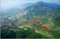
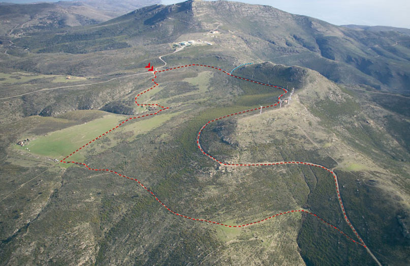
ROUTE:
As you go down the highway
joining Roses with Cadaqués,
take the turn-off to the
right that leads to the El
Pení air base. Two kilometers from
this turn-off, and after
having left your vehicle
in a small parking lot, take
the dirt track that climbs up.
A new path branches off to
the left some 200 meters
after taking the dirt track.
Follow this path a few
meters to enjoy a
magnificent view of the Norfeu
Cape in all its majesty. The
site is registered as a
natural reserve of the Creus
Cape Natural Park, and
it is characterized by a
great richness of flora and
fauna, both on land and
underwater. You will also
come across the remains of a
cremation site built by
Indo-European tribes in the
8th century BC.
Return to the initial track
and take it up to peak Puig
Alt. From this location you
can also enjoy one of the
site’s most beautiful views:
the Bay of Roses on one
side, and the Cala Montjoi
cove on the other.
The route continues
bordering the Puig Alt and
then makes a turn of almost
360 degrees to arrive at the
Font de la Bich, with a
water fountain and a
drinking trough for animals.
Beyond the fountain, you
will discover a magnificent
view of the town of Roses
before the path takes you to
the crossing of Pla de Can
Caussa, in honor of the
farmhouse which gives its
name to this plain. This is
a good spot to stop and rest
a bit and have a bite to
eat.
From here on, the site you
will see is the exact
opposite view of the Bay of
Roses, namely the northern
edge of the Creus Cape
with the waters of the Mar
d’Amunt in the background.
A little further ahead you
will reach a little dip with a
grove of trees that gives
its name to the nearby
building: the Mas dels
Arbres (literally, the
"Trees Farmhouse").
Finally, you will return to the
starting point, where you
left your vehicle, after
having taken a route that
has shown you views to the
north and south of the Creus
Cape, with all its
splendorous beauty laid out
before your eyes. |